






Langtang Valley Alternative Route Trek
08 September 2026
By admin
The Langtang Valley Trek has always been one of Nepal’s popular trekking destinations well known for its glaciers, Tamang culture and its closeness to Kathmandu. For many years, the traditional way to start the trek by reaching Syabrubesi, then trek to Lama hotel and Langtang village before reaching Kyanjin Gompa.
The traditional route largely dependent on the road going through Betrawati and Dhunche in the Rasuwa District. After the flash flood that occurred in this area in August 2026, most important part of this road has been badly damaged, as well as the town of Syabrubesi. This has made it difficult to use this route for now.
Here is where an Langtang Valley alternative route trek comes into play. Trekkers will be able to avoid the area where the damages took place using the alternative route and arrive at their destination.
But this is not just an alternative, as the alternative route through the Langtang Valley also provides a unique trekking experience via quiet trails, leading to the area of Gosaikunda.
The purpose of this guide is to provide the information necessary for trekkers who have learned about the access problems and need to have accurate information prior to their booking. This will help whether you are planning your trek to the valley or altering your existing booking.
What Happened to the Traditional Syabrubesi Route?
The traditional trekking routes to Langtang Valley consisted of taking road route from Kathmandu via Trushuli Bazaar, Betrawati and Dhunche and then travelling further up north toward Syabrubesi and walking through Lama Hotel and Langtang Village before reaching Kyanjin Gompa.
Then in August 20206 came a massive flood towards Rasuwa district and altered the pattern of the Langtang Valley Trek. There was extensive damage to bridge and road section in the Bhote Koshi river system affecting Timure, parts of Syabrubesi and Betrawati-Rasuwagadhi road.
Let us be more specific here. The flooded sections are part of the Bhote Koshi corridor that provides access to Syabrubesi. The Langtang Valley trekking trail, however, is located on another river system known as the Langtang Khola. Initial reports indicated that there was no damage done to the valley or its trails.
So, the real problem is not trekking but the means of transport to getting to the old starting point is becoming increasingly tough but the conditions for walking inside Langtang Valley is in good shape from what we’ve heard recently.
How long the disruption will last is not entirely known as the restoration of the infrastructure depends upon the evaluation and funding. Some parts might open up in a few weeks, whereas others would require more time to do so.
Current Trail Update: There may be changes in the condition of the trail and roads based on weather, landslide, flood, and local infrastructural condition. Trekkers are advised to check for up-to-date information regarding the route. At Epic Trek Nepal, we keep a record of all up-to-date information and suggest an alternative route to Langtang Valley or Langtang alternate route accordingly.
Is Langtang Valley Currently Accessible?
Of course, Langtang Valley is reachable, although the route which trekkers use has been changed temporarily. Only the starting regular access by road has suffered but the valley and the trail are still untouched.
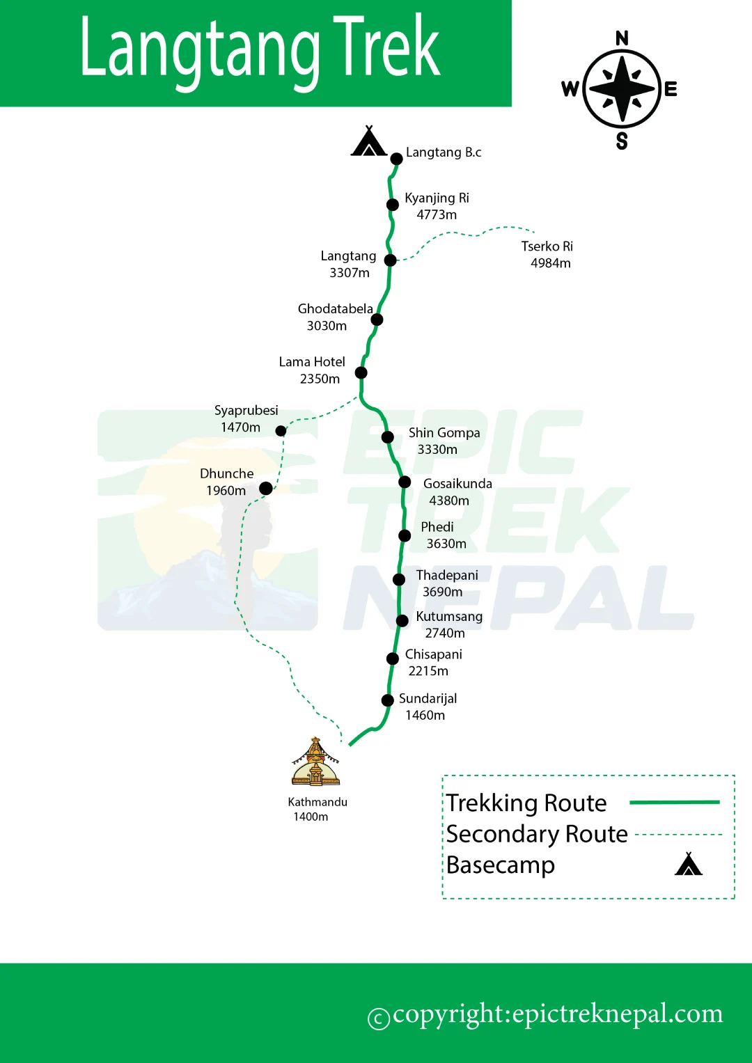
Currently, Sundarijal area provides the most reliable access to the destination. The trek starts with a walk along the ridge trail from Kathmandu’s via Chisapani and Thadepati to the point where it connects to Goasaikund and further to Langtang Valley.
The transportation to the traditional starting point in Syabrubesi is unreliable due to flood. So, the trekking route of the Langtang Valley alternative route trek will include additional walking part that should be done without vehicle.
The mentioned alternative route is not an unofficial way of access, but a path recommended by the official trekking agencies of Nepal for the current season. However, this route involves some more days of trekking than the drive to Syabrubesi.
There are no changes in the permits required. You will still be required to have a Langtang National Park entry permit as well as the TIMS card, both of which Epic Trek Nepal will obtain in advance irrespective of whichever route you choose.
For the most up-to-date information, always contact a licensed trekking agency like Epic Trek Nepal or the Trekking Agencies’ Association of Nepal (TAAN).
Langtang Valley Alternative Routes
Even through the main route to Langtang Valley has been temporarily blocked, there are still other alternative route to Langtang valley that you can choose.
Alternative via Gosaikunda and Helambu
The trek starts from Thulo Syabru where you need to walk from Sundarijal side instead of reaching directly to Syabrubesi by road transport. Further, the route passes through rhododendron forests in the direction of Gosaikunda, which is a holy lake located at an altitude of about 4,380 meters.
The most difficult part of this trail is to cross Laurebina La Pass that is located nearby 4,610 meters. Then the trail comes down through Thulo Syabru to join Langtang Valley trail near Lama Hotel. The trail further follows the known Langtang valley trail from here through Langtang Village to Kyanjin Gompa.
This variant of the trail is preferable for trekkers who are looking for the real high-altitude trekking experience and ready for additional days on the way.
Via Sundarijal
This is the most practical alternative route to Langtang Valley because it avoids the road that was damaged due to the floods completely. It begins straight from Kathmandu as there is no need to make long treks by jeep or buses to reach its starting point.
From Sundarijal, this trek will go up to Chisapani and further through the Helambu area. This trek is through villages of Sherpa and Tamang communities with less crowd compared to the regular Langtang trekking route.
After Helambu, this trek will merge with the path towards Gosaikunda after which it descends to Thulo Syabru and merges with the regular Langtang trekking route.
Via Tamang Heritage Trail
This is a good itinerary for trekkers looking for more culture in addition to the Langtang Valley trek. The trek doesn’t go directly to the Langtang Khola valley but goes through villages such as Gatlang, Tatopani, and Nagthali before joining the main trekking trail.
The Tamang Heritage Villages in this region still sticks to their traditional architecture and way of living. Therefore, it will provide you with a better understanding of the area than the busy path of the Langtang Valley trek. You can enjoy the hot spring water in Tatopani after trekking for a few days.
Alternative Treks to Consider Instead of Langtang
If you still have doubt about Langtang valley trek, timing or difficulty problem from going on a trek to langtang, there are some other treks around there that provides the same experience of the Himalayas without the current uncertainties.
Helambu Trek
It is a less challenging trek which starts along the same path as the Langtang alternative path through Sundarijal and does not go to high altitude, so, it is perfect for those who want to enjoy the mountain views and Sherpa/Hyolmo culture without the challenges of Gosaikunda and Kyanjin Ri treks.
Ganesh Himal Trek
A trek that lies west of the Langtang area, the Ganesh Himal trek offers equally amazing mountain views but with very few crowds. The accessibility through Dhading Besi has not been affected by the current floods and will be a reliable alternative for you.
Tamang Heritage Trail
This trek can be taken separately from the Langtang Valley and is short, culturally interesting, not difficult, and includes hot springs, villages, and mountain views.
Manaslu Circuit Trek
For those interested in trekking through more difficult terrain, the Manaslu Circuit is still open for exploration without any problem related to the flooding in Rasuwa. Though it is slightly longer and needs a permit for a restricted area, the Manaslu Circuit trek offers spectacular mountain scenery and a crossing of the tough Larke La Pass.
Trek in Annapurna Region
If you would like to trek in an area away from Rasuwa this season, then Annapurna Base Camp and Poon Hill Trek are good options for you, as they have proper infrastructure and a whole new adventure awaits.
No matter which trek you choose, we at Epic Trek Nepal can assist you in comparing trail conditions.
Classic Langtang Route vs Alternative Route
Here is a comparison between the traditional route and the alternate route to Langtang Valley Trek that is in use today.
| Feature | Classic Route | Alternative Route |
| Starting point | Syabrubesi | Sundarijal or Thulo Syabru, depending on route |
| Duration | 7–8 days | 10–12 days |
| Difficulty | Moderate | Moderate–Difficult |
| High point | Kyanjin Ri / Tserko Ri (~4,984 m / 5,000 m) | Can include Laurebina La (~4,610 m) |
| Main attraction | Langtang Valley | Helambu + Gosaikunda + Langtang Valley |
| Culture | Tamang culture | Tamang + Helambu (Sherpa/Hyolmo) culture |
| Altitude gain | Moderate, gradual | Steeper, with more daily elevation change |
| Best for | First-time trekkers | Experienced or adventurous trekkers |
Langtang Valley Alternative Route Trek Map
Difficulty of the Alternative Route
The alternate trek is a bit difficult that the classis Langtang Valley Trek. It is classified as a moderate to difficult level which doesn’t tell you much about how challenging the trekking path is. Below, we list some differences between the two paths to see why the Langtang Valley Alternative Route Trek is harder than the Langtang Valley Trek.
Firstly, daily walking distance can increase up to 6 to 8 hours compared to 5 to 6 hours on the traditional path. In some day, it would require you to walk for many hours while climbing and then descending.
Another difference is the presence of regular ascents and descents that might be quite steep around such places as Chisapani, Tharepati, and Gosaikunda. It means that you will feel tired not only when walking up but also going down because the trek is quite hard on your knees.
High-altitude areas present challenges of their own. If you trek beyond the altitude of 4,000 meters at the Gosaikunda region, you will experience how thin the air is and how hard the simplest task of walking uphill feels. The trail conditions are not consistent as well. Sometimes they are perfect stony steps and sometimes muddy/loose soil after the rain, especially in monsoon shoulder periods.
As compared to the classic path, the weather plays a bigger role for this path, since you will spend most of your time at higher altitudes where you will feel strong winds and sudden drop in temperatures. Morning is usually clear but cloudy skies start appearing in the early afternoon.
For this reason, good physical condition is essential. While you do not have to be an experienced climber, cardio training is helpful. It is not necessary to have previous trekking experience, but it will make things easier for you.
Safety and Current Trail Conditions
As of now, the situation in the Langtang Valley is developing further, even now since the flood in August 2026, so let me give you an up-to-date picture on the matter. There is weather condition that should be taken into account when traveling. The morning is usually sunny and clear, but then clouds come later during the day and bring occasional rain due to monsoon until September.
There still is a danger of landslides in certain parts of Rasuwa-Nuwakot, especially those that were flooded near Syabrubesi and Betrawati. An alternative route from Sundarijal and Helambu has not faced such difficulties, and that is the reason why it is considered a safer choice now.
The known areas affected by the flood damage include the Bhote Koshi area, specifically Timure, Syabrubesi, the Betrawati-Rasuwagadhi route and some of the bridges in this area. Within Langtang Valley, on the Langtang Khola route, the trails and bridge are still safe.
Altitude comes into play when it comes to Langtang alternative route, as areas that have an elevation of 4,000 meter or even higher, such as Gosaikunda and Laurebina La have the typical danger of altitude sickness.
Guided treks are required in this case, and this is especially true at this moment in time, considering the extended and unfamiliar route of the trip. The guides and porters know what is happening currently with the trail conditions, water level changes, and weather changes.
For any safety information before you start your journey, contact Epic Trek Nepal or TAAN.
Conclusion
There is a very clear reason why the Langtang Valley alternative route makes sense at this point in time. Since the regular Syabrubesi trail has been affected by flood, the Langtang Valley alternative route trek gives a safe way to get to one of Nepal’s most stunning valleys.
This alternate route to Langtang valley is for those who wish to see Langtang region, but due to flood, it wouldn’t be possible to use the classic route. In contrast to the classic Langtang Valley Trekking Route, it will take more time, altitude difference, and exploration of other sites like Gosaikunda or Tamang Heritage Villages.
Would you like to do a Langtang Valley Alternative Route Trek with a guide? Our team from Epic Trek Nepal is happy to provide you with the route, permits, transport, accommodation, guide, and itinerary based on the trail status.
Frequently Asked Question
What is the alternative route to Langtang Valley?
An alternate Langtang Valley route is one that connects to Langtang Valley by avoiding the usual Syabrubesi drive-in entry point.
Can Langtang Valley be trekker without taking the Syabrubesi route?
Yes, it is possible because there is now alternate Langtang Valley trekking route that starts from Sundarijal.
What is the duration of the alternative Langtang route?
The alternative route can take 10-12 days whereas the usual route requires 7-8 days, depending upon the added distance covered while trekking.
Is the Langtang Valley alternative route tougher that the classic route?
Yes, the alternative route is tougher than the classic route due to the long trekking hours and high-altitude pass such as Laurebina La.
Will the alternative route go through Laurebina La Pass?
Yes, it will, but only if you choose the variation with Gosaikunda pass. Other alternative routes skip it.
Which is the highest point of the alternative route?
The highest point of the route is normally Laurebina La Pass, which is located at about 4,610 meters.
What kind of permits do you need?
You will require the same permit as the Langtang Valley trek to complete which include Langtang National Park and Tims Card.
Will it be possible to combine the Tamang Heritage Trail with the Langtang Valley Trek?
Yes, this is a popular combination that allows visitors to experience culture while hiking before taking the route to Langtang valley.
Do I require a guide?
A guide is necessary because it is the law in Nepal for anyone who is going for trekking, particularly since there are some problems with the route at the moment.
Is the Langtang Valley trek route open now?
Yes, this valley is still open. However, the classic access road from Syabruesi is currently unavailable because of the floods. The alternate route is available.

Table of Contents
- What Happened to the Traditional Syabrubesi Route?
- Is Langtang Valley Currently Accessible?
- Langtang Valley Alternative Routes
- Alternative Treks to Consider Instead of Langtang
- Classic Langtang Route vs Alternative Route
- Langtang Valley Alternative Route Trek Map
- Difficulty of the Alternative Route
- Safety and Current Trail Conditions
- Conclusion
- Frequently Asked Question